Big Sur: USA Holiday Part 4
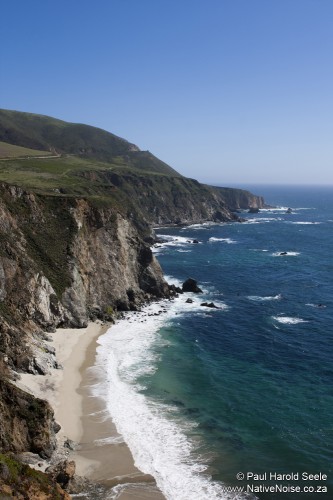
After Carmel, HWY1 turned into the very scenic but slightly nerve racking cliff-side trail. The Big Sur coastline is absolutely exquisite. Lush green forests rest atop powerful rocky cliffs that plunge straight into the crisp blue Pacific.
Stopping to take in a beautiful view I spotted a spurt of water shooting out of the sea. I called Ana-Paula to come and see the whale which lead to a conversation with a lone American traveller. We got chatting to the Los Angelino who told us about the treacherous road we’d have to take to avoid the road closure. After chatting for a few minutes he pulled a CD out of his car and gave it to us. This was Terry Wilcox’s roadtrip mix No.16. We could have the CD under one condition, if we don’t like it after three listens then we need to pass it on to someone else. The Big Sur has pretty barren airwaves so we graciously accepted the CD and got back on the road. It turns out that Terry Wilcox makes very apt roadtrip mixes. The CD was a great collection of unfamiliar Bluegrass, Folk, Americana and even a few Mexican songs – the perfect companion for our trip through California.
Before leaving the UK we read that part of HWY1 was closed due to heavy rainfall causing a rockslide. Knowing that the road we were on had recently slipped into the ocean was not the most comforting idea. Before setting off from The Sunset Inn we’d been assured that the road had reopened. At the start of the journey I was fairly certain I’d seen a sign warning of a HWY1 closure, but the further we drove the less likely this seemed. It was only when we were approaching our hotel that we saw signs saying ‘HWY1 closed in 10 Miles – Business as usual’. Without being certain how far away our hotel was, we got more and more concerned as we kept driving. Panic set in as we reached the point where the road was closed, until we realised that the hotel was on our left.
The Gorda Springs Resort was the most expensive accommodation on our trip, so we were really disappointed with the state of it. The tap water was undrinkable (2 bottles were provided), the room had been tidied but was grubby and in desperate need of a deep clean. The restaurant was closed so we couldn’t have any dinner and breakfast wasn’t included. While we had booked for two nights, we decided we’d rather spend our second night elsewhere so we checked out the next day.
Having skipped dinner we woke up starving and went in search of a big Big Sur breakfast. After driving up and down HWY1 we eventually found Deetjins, an amazing collection of bungalows buried in the forest. They served up an incredible breakfast and we liked the place so much that we decided to ask if any rooms had become available due to the road closure. Unfortunately they only had a premium cabin available, it sounded amazing but was more than twice our budget so we decided we’d leave the area after a decent bit of exploring.
Big Sur is made up of numerous state parks that all feature amazing walks and hikes. We stopped off and wandered around Julia Pfieffer Burns State Park which is home to a beautiful isolated beach and a waterfall that pours straight onto the beach. Some brave soul had reached the inaccessible beach to write ‘Jessica, will you marry me’ on the sand. It’s hard to imagine her turning him down.
Next we went to check out Sand Dollar Beach. Despite the sunshine, it was a far cry from being warm enough to swim so we just chilled on the beach for a while.
The road closure meant that we couldn’t continue South along HWY1 and the SatNav claimed that our fastest route involved going all the way back to Carmel and taking HWY101. We weren’t looking for the fastest route. the traveller we’d met the day before told us about the mountainous road out of the area so we decided to take the scenic route. It certainly was scenic, but equally terrifying. The road wound all the way up the steep cliff edges, with no trace of any protective barriers. Driving South on the right hand side of the road meant that our car (and particularly Ana-Paula’s window) was on the edge of the road and closest to a deadly plummet. Creeping up the road at 2-5mph was fine until we encountered the occasional massively American oncoming vehicles, which always felt like squeezing a camel through the eye of a needle – while an elephant rushed through from the other direction.
Part of our detour included passing through a military training area. It was fairly inconspicuous until we spotted a giant tank in the middle of the field.
